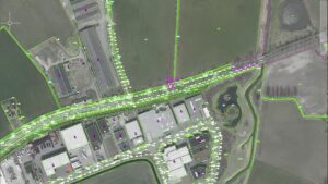
GIS digitization is a critical process in creating digital maps and GIS data layers, and it has several important benefits, including:
-
Improved data accuracy: GIS digitization allows for the creation of accurate digital maps with precise location information. Digital maps can be easily updated, maintained, and shared, reducing errors and inconsistencies in data.
-
Better visualization: GIS digitization provides the ability to visualize data in a variety of ways, including maps, charts, and graphs. This helps to improve decision-making by providing a clear and comprehensive view of spatial data.
-
Increased efficiency: GIS digitization automates many of the manual processes involved in creating and updating maps. This reduces the time and resources needed to produce and maintain maps, allowing organizations to work more efficiently.
-
Easy integration with other data sources: Digitized GIS data layers can be easily integrated with other types of data, such as demographic or economic data. This enables the creation of more comprehensive and insightful analysis.
-
Better communication and collaboration: Digitized GIS data can be easily shared across organizations, teams, and departments, allowing for better communication and collaboration. This promotes more informed decision-making and improves overall productivity.
In summary, GIS digitization is an important process that helps organizations to create accurate and comprehensive digital maps, improve data visualization, increase efficiency, and enhance collaboration and decision-making.