Agriculture and Development Support Programme.
Research Areas -Agriculture & Allied Sectors
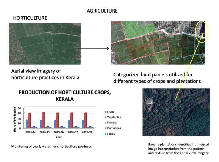
Agriculture or farming constitutes of land availability, soil type, precipitation, moisture, climatic conditions and the accurate ways and techniques of farming. Implementing GIS technologies have helped the farmers in monitoring and estimating their yield product. GIS has the capability to select crops as per the soil properties and climatic conditions and also analyze the ways of maintaining soil nutrition. Agricultural GIS technology has helped farmers to map and project current and future fluctuations in precipitation, temperature and crop output. The technology is enabling the farmers to create more effective farming techniques, utilization of fertilizers for more and higher quality of food production.
Geospatial Application in Agriculture:
Real-time crop yields:
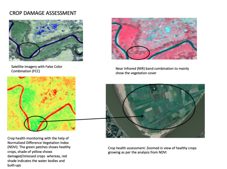
Shifting to real-time crop monitoring and targeted, automated responses with drones, land use products such as Glob cover map, MODIS-JRC crop mask, monitoring Agricultural Resources (MARS), USGS cropland use intensity datasets, USGS land use/land cover and precision watering sensors will be a benefit in estimating crop yield. Use of multispectral and hyperspectral satellite data such as Quick bird, Sentinel-2(10-20 m resolution), MODIS for calculation of NDVI,EVI, NDWI with the help of Near infrared(NIR), Red and Blue bands for monitoring crop health and availability of water. Real-time crop forecasting can also be done using Earth Observations Global Agricultural Monitoring Initiative(GEOGLAM), USDA Famine Early Warning System Network(FEWS NET) and FAO Global Information and Early Warning System(GIEWS).
Assimilation model :
Assimilation model using simulation of soil, water and crop process helps in better understanding crop productivity and monitoring using the crop assimilation model tool in GRASS GIS. With the launch and availability of multi-spectral sensor satellites (Landsat, SPOT, IRS) remote sensing data has become an important tool for yield modelling. An integration of crop simulation models, Remote Sensing data and Geographic Information System can provide an excellent solution to monitoring and modelling of crop at a range of spatial scales.
Plant hardiness :
Hardiness of plants describe their ability to survive adverse growing conditions by defining distinct boundaries in which plants are capable of growing as defined by climatic conditions. The U.S. Department of Agriculture’s released Plant Hardiness Zone Map (PHZM) incorporates greater accuracy and detail available in various digital image formats and as an interactive online mapping application which allows users to see the relationship between the underlying topography and localized differences in plant hardiness zones.


Precision farming :
Precision farming is harvesting more crops per acre while spending less on fertilizer using different farming techniques and software. Drones with data-gathering equipment for agriculture are one such concept for precision agriculture. Drones can be used with different imaging technologies like hyperspectral, multispectral, thermal, etc can provide farmers with time and site-specific information regarding crop health, fungal infections, etc. Drones can also identify drier regions in a field and measures can be taken to irrigate such regions with better techniques.
Current food security :
Food security is safeguarding food insecure populations by establishing underlying causes through satellite data, mobile-collected and GIS storage data. GIS and Remote Sensing technologies such as satellites and software can be used to gather and map data concerning soil fertility, elevation models, population, food production and landsat images. Correlating these data sets and analyzing them with GIS techniques is useful in analyzing changes in the climate and their effects on agricultural production.GIS and Remote Sensing systems are also able to monitor changes in climate and demonstrate its effects on soil fertility, rainfall, growing conditions and approaching food shortages. Remote Sensing systems such as the SPOT-4 and 5 satellites identify disaster prone areas where changes in vegetation may become insecure. The FAO ARTEMIS is a widely used system to monitor food supply and demand conditions for proper preparation.
The leaf area index (LAI) defined as the total one-sided leaf area per unit ground area is one of the most important parameters characterising a canopy. Remote Sensing based LAI estimation would greatly aid the application of LAI as input to models of photosynthesis, crop growth and yield simulation models, evapotranspiration, estimation of net primary productivity and vegetation functioning models for large areas. In the field of vegetation mapping, the most commonly applied sensors include Landsat [Thematic Mapper(TM) and Enhanced Thematic Mapper (ETM+) NOA-AVHRR and SPOT-VEGETATION, LISS-III and MODIS .
